

I propose a new trip to sunny Ticino.

The main point of destination is the city of Lugano, from there you can go and visit the Swissminiatur and Monte Brè. Other variants of the destinations can be the city of Ascona or Locarno, where the famous film festival is held. Lakeside towns have a special charm. Ascona and Lugano are my favorite destinations, considering that I spend a lot of time in the mountains and miss the sun and heat (statistically throughout the year), and the sun is abundant in the southern part of the Alps. In this area, the temperatures are much higher and the vegetation is Mediterranean.

It is a round trip of 5 hours by car, but very pleasant. We will go through the Gotthard tunnel. And through other small tunnels before the Gotthard, someone counted them and said there were 36.
The departure time to Lugano from the canton of Ticino must be chosen carefully because the Gotthard Tunnel, which separates the northern and southern parts of Switzerland through the Alps mountain range, is generally very busy. That’s why I recommend that you look at Google Maps to set the departure time so that the traffic through the tunnel does not appear with a lot of red. My recommended time is before or around 07:00 in the morning.
We start from Engelberg, a mountain resort located at an altitude of 1000 m in the canton of Obwalden, from where we descend to Wolfenschissen and Dalenwill, canton of Nidwalden. These two cantons were united and were called Unterwalden. This Unterwalden together with Uri and Schwyz form the Swiss nest from which Switzerland as a nation was formed. The departure area is located in the center of Switzerland, where I also live.
View from Stanshorn, behind is Lake Lucerne

Further on, we pass through Stans, which is the capital of Nidwalden Canton. After exiting the highway to the right, we will travel along the shores of Lake Vierwaldstetten.

Vierwaldstetensee (also called Lucerne) is a large lake in central Switzerland, the third largest lake in terms of area and the second largest tourist attraction, and stretches, as the name suggests, across four cantons and has some very beautiful landscapes, I recommend especially a tour of this lake or boat rides. The largest lake in Switzerland is Neuchatel, followed by Constantz and then Lucerne. Indeed, in terms of the total area of the lake, the largest lake is Lake Geneva shared with France, then Constantz with Germany.

Then we pass through the Seelisberg tunnel. In Switzerland there are about 1300 tunnels and galleries with a total length of about 2000 km.
Slow down before entering this tunnel as radar is installed. In general, there are only fixed speed cameras, in the Engelberg area, to avoid getting speeding fines because they are 3 times more expensive than in the next canton. There are still radars in Lucerne, and towards Engelberg, so the feast is slow.

If you want to relax while traveling on the road and want to try a traditional station with Swiss music, look for the Central Switzerland program.
At the exit of the tunnel, we pass the capital of the Canton of Uri, Altdorf, and we turn to the right, following the southern course towards sunny Ticino. Here are some flags of the surrounding cantons.


The north side of the tunnel is generally cloudy, so after passing through the tunnel you will enjoy the much sunnier south side.
The travel duration to the tunnel is one hour. On the left is the canton of Uri, with some very impressive mountains. Many times, if the highway is very congested, it can be easily bypassed on the national roads past Altdorf and you arrive right in front of the tunnel.

From Wassen take the exit to the Susten pass. This pass connects Wassen in and Inetkirchen and is open from June to October. This pass has been known since the 1600s as a trade route. During the war years of 1798 and 1799, the Susten Pass was used several times by the French to attack the Austrians and later the Russians in the Reuss Valley. The construction of a passable road through this pass began in 1811 and lasted 100 years. Obviously, the river we pass is the Reuss River which also reaches Fislisbach, and later flows into the Rhine.
Also, from Wassen there is another road to Furkapsas which is further south of the Sustenpass. The etymology of the name for us Romanians is simpler in the sense that we think of a fork and the road from Wassen through Furkapass forks north to Innertkirchen from where you can go back in a circle or south and go to Saas Fee in the canton Wallis. This step is open between June and November. It is particularly beautiful, it reminds us of the Transfăgărășan route.

Once we arrive at the Gotthard Tunnel, we have to arm ourselves with some patience to cover the 17.5 km and we will notice that the air temperature in the tunnel reaches 33-34 °. The exit from the south is called Airolo and from there the Swiss expression Airolo (tunnel) means something that passes through your ears but does not stay in your mind, just like the traffic through the Airolo tunnel which is not allowed to stop. Gotthard has 3 tunnels, two for railway traffic and one for car traffic.

The construction of the railway tunnel began in 1871 and lasted 11 years. The car tunnel was opened in 1980 and until then, cars were transported by train. A 2nd railway tunnel called GBT (oh, not related to … is the acronym Gotthard Base Tunnel) and was opened on June 1, 2016 after a construction that lasted 17 years. The base tunnel has a length of 57 km and comes out of the mountain in the southern part somewhere below ours, in Biasca. This is the longest tunnel railway in the world, the deepest traffic tunnel and the first flat, low-level route through the Alps, the second-longest tunnel being the Channel Tunnel.
For a list of the longest tunnels visit https://en.wikipedia.org/wiki/List_of_longest_tunnels
1 km from the tunnel exit you can take a break at the Gottardo Sud gas station.

To the left is a trail to Lago Ritom, a natural lake on top of the mountain that is used by the Swiss SBB railways to generate electricity for the electric railway in the area. The lake and the nature reserve are located at 1850 m. The lake is meromictic, that is, it has layers of water that do not mix with each other. This type of varnish is rare, 1000 times more than the classic one. As a matter of curiosity, the Black Sea is the largest meromictic basin in the world, here is one thing, the largest in the world…😊.

Let’s go further south and we reach Bellinzona which is the capital of the canton of Ticino where from the highway you can enter a gas station with a Marchè store that caters to the most demanding customers.

Then follows the bifurcation between the road to Locarno with the famous Lake Maggiore and the Lombardy area to the right and the road to Lugano with the lake of the same name, Lugano, still ahead.
We continue from Lugano to the small town of Melide where the Swissminiatur is located.
Here we find the most important places and tourist attractions in Switzerland represented in miniature size.


We continue back north to Lugano where we will arrive in about 20 minutes on a lakeside road.
Here are the following attractions
Lugano car park: Autosilo Central Park
Parco Ciani


Paradiso, the lakeside district, Lido where you can swim, and the beach.


Through the Ciani Park behind the Lido you can walk upstream with the river that flows into Lugano.
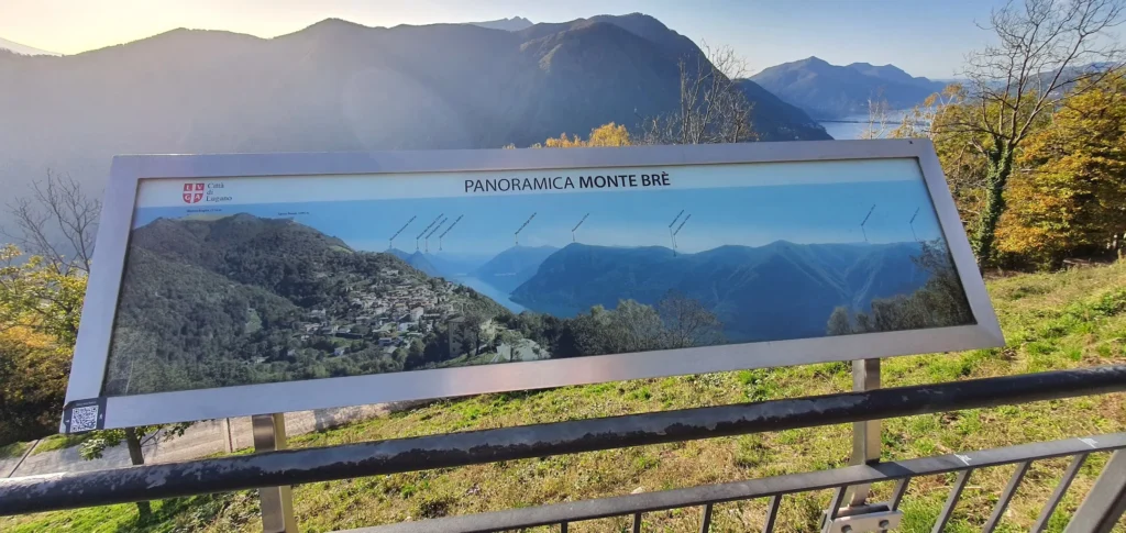
Gandria where is the Sentiero dell’olivo. Up at the top is the panorama restaurant in Monte Brè

Sentiero dell’olivo, with the history of olive trees It is my favorite place to walk. A walk to the farthest point takes about an hour and a half. Here you can park your car (it is located between 2 parking lots) quite cheaply and the road can be covered on foot or by ferry between the stations. If you buy a full tour that costs around 20 francs with that ticket, you can stop at every station, the ticket being valid for a full tour and thus you can also visit the city. I recommend parking here because in the city parking in the city is relatively expensive.


The boat ride is a tour that takes about an hour. There is also a big boat tour on a longer route over 2 hours that also goes to Italy, but I didn’t do that one.


In Sentiero dell’olivo I mention the restaurants where you can eat at reasonable prices, places to swim, the rowing club, walks in two olive groves, the groves being to the side, towards the access ends. There is only one toilet halfway, where you can also find water from the fountains.
Monte Bre. It can be reached by car, it’s a winding road that takes about 1/4 hour and up the mountain you can take a few walks through the chestnut forest.


Monte San Salvatore, din oraș diametral opus lui Monte Brè. Se spune ca daca urci pe jos pana in vârf, cam 2 ore ți se va împlinii o dorință.

The restaurant near the station.
The Church of Santa Maria degli Angioli from the center towards the lake.

San Lorenzo Cathedral

The old City
The funicular that goes to the station

The cable car that goes up to Monte Brè

The Museum of Art and Culture LAC where the entrance costs about 12 francs.

Reform Square

Lido San Domenico, a beach with grass :). Ok, it just came like that… LSD

If there is still time, go up to Monte Brè by car. The parking lot is quite large. At the top, you can take a walk through the chestnut forest to the funicular. There is an old church and a restaurant with a panoramic view. You can also walk under the terrace of the restaurant.

Then the way back, you don’t have to hurry, an hour later has the advantage of the free road.